Thursday, August 18, 2022

Retreat to Roaring Plains West Wilderness

This is the Roaring Plains West Wilderness--a remoter and lesser-visited alternative to Dolly Sods.  I did indeed retreat to this lonesome place.  Getting there was no easy task, since the bridge across Red Creek is out, which I discovered the hard way; I had to drive all the way round to the Bear Rocks entrance.  (I forgot to bring my excellent Purple Lizard map and thus missed out on the Forest Road 19 entrance, which I vaguely recall taking long ago.)  My goal was to set up a little camp in the wilderness where I could read, and think, and just be--which is so unlike the hurried, stressful thing I was trying to do on the Standing Stone Trail.  Roaring Plains is an excellent place to go if you just want to sit beneath a rainfly and...be.  Because the bridge was out at the south end of the Sods, there was absolutely no one anywhere near the little gated Forest Road 70, south of the Sods, which leads three miles into Roaring Plains.  Driving south along the perimeter of Dolly Sods, I only saw two other cars beyond the public campground.  After that, it was about six miles of absolute solitude.  Arriving on a Sunday afternoon, it felt eerily and sweetly abandoned, and in fact I saw not another human being till Wednesday afternoon.
The road is just a little grassy lane, closed to motor vehicles, but it makes a quick expressway to the Roaring Plains, much faster than the trails which also go in.  After three miles it meets a gas pipeline swath that cuts through the forest, and just across the swath, the Roaring Plains Trail plunges into the woods.  It was here I made my camp, at the second site just inside the forest and very near to a beautiful little stony brook whose waters run tea-colored from the tannins in the hemlocks.  It was so nice to be in a place where there was water--unlike Central Pennsylvania, where a drought put an end to my last foolish woodland venture.  (If interested in that tragicomedy, go HERE.)  The purpose of this trip was mostly to serve as a retreat, so I made a far more luxurious camp than usual.  I brought my big two-person tent, which I rarely use anymore, in addition to my hammock tent, plus a small folding chair and three books!  Heavy books!  1) Jesus and John Wayne: How White Evangelicals Corrupted a Faith and Fractured a Nation, by Kristin Kobes Du Mez--very highly recommended.  2) The Complete Fairytales of the Brothers Grimm, a massive paperback which alone weighs 2 lbs.  I'm interested in fairytales as folk mythologies, and there's a whole lot more to the Grimms than Snow White and Sleeping Beauty.  3) My handwritten journal, which I've kept since the beginning of my sabbatical on June 1.  I knew that I'd only be carrying the pack for three miles on a relatively easy surface, so I didn't mind the weight.  It was still far lighter than carrying all that water on the Standing Stone.  I didn't make a fire.  It was rainy, so I just set up the folding chair beneath the rainfly of the hammock tent and read and journaled until about 7:30pm, when I settled into the spacious two-person tent to read and watch a movie that I'd downloaded onto my phone.  I know it's cheating, but I love to watch movies when I backpack alone...  It was chilly, and it rained all night, so it was fun to lie inside the warm tent and catch a flick.
Monday, my first full day on the Roaring Plains.  It didn't rain all day, but the fog was outrageous and blinding.  It was both stifling and exhilarating.  I had intended to explore the wilderness area a bit, but the thick mist that settled over these high plateaus made that impossible.  There were no vistas; everything was socked in.  But in a way it was fun being locked into my campsite, sitting under the rainfly to shelter myself from the dripping of the trees, sipping coffee, gazing out into the mysterious and partly hidden forest, all the while reading medieval German folklore about...misty forests where people get lost, or meet ogres, or come upon enchanted castles or witches.
By evening I had begun to feel a little depressed by the fog.  No, not "depressed."  I felt "oppressed" by it.  It was fun early in the day, even comforting.  But it was dank and chilly, and it placed so many limitations on what I could do.  I thought a fire would be just the thing to drive away the foggy gloom and cold, but alas!  Wet conditions are such a part of life in these highlands that all the wood I could find was "punky."  That's to say soft and waterlogged.  In fact, the fire ring at my campsite had evidence that the camper before me had the exact same problem--charred branches, but none of them burned to ash.  I got a small fire going for about an hour.  Strange how companionable a fire can be!  Surely civilizations, and societies, and the stories that define us all originated around prehistoric campfires.
Tuesday morning saw the same clouds lingering over the forests, but they lifted in the afternoon.  Having forgotten to bring a map, I formed a theory that if I followed the pipeline northward, away from the great rim that overlooks the world, it would join up with the other end of the Roaring Plains Trail.  My goal was to catch some view of the legendary Mount Porte Crayon--where there is no path.  The only way out to it is on the far end of the Roaring Plains Trail, but I didn't want to go there.  Not yet.  I just wanted to see it.  
I was wrong.  The swath does not cross the Roaring Plains Trail, but it was a pleasant walk out to the heliport, which is used for emergency evacuations of hikers who come unprepared, or who fall into crevasses, or get mauled by bears...  Mt. Porte Crayon is named after a local man who became a well-known illustrator and writer in the 19th century and went by the pen name "Porte Crayon," which means "Carries Pencil" or "Pencil Box."
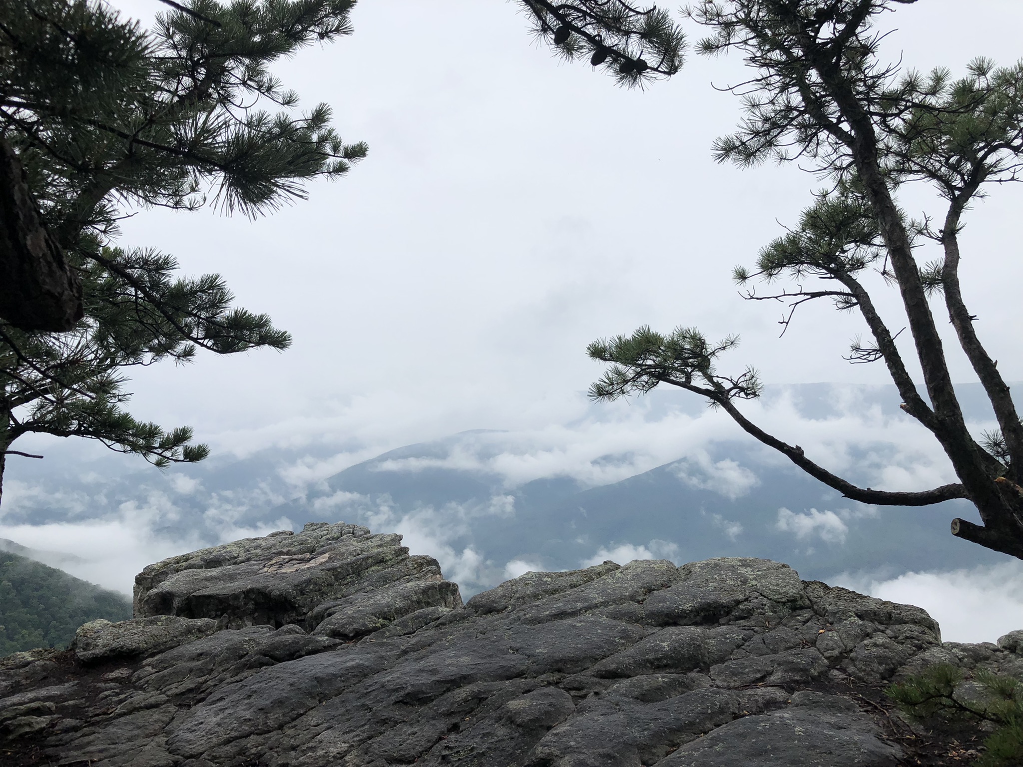
But Mt. Porte Crayon eluded me that day.  Instead I decided to make my way to a place called the Sliding Board on the Boar's Nest Trail.  It's a place where the trail, already wet and slippery, comes to an extremely steep descent--a sliding board.  I'd read that there were good views out over the wooded southern end of Dolly Sods from the top of the sliding board.  This, too, was about a three-mile hike.  But it was wet, and my feet got soaked.  Here's Breathed Mountain and "Lion's Head" in Dolly Sods.
This is another view from the top of the Sliding Board.  Breathed Mountain is surely named after some long forgotten family who once owned it.  When it's a family name, the word "Breathed" is pronounced in such a way that it would rhyme with the word "Tethered" if you said it with a British English accent: TEH-thed, BREH-thed.  I always tell other hikers this when they pronounce the name like the past tense of the verb "breathe," as in, "Mom, he breathed on me!"  I get blank looks.
One of the pleasures of hiking in the Sods or Roaring Plains in mid-August is the wild blueberries!  They're everywhere, small and flavorful.
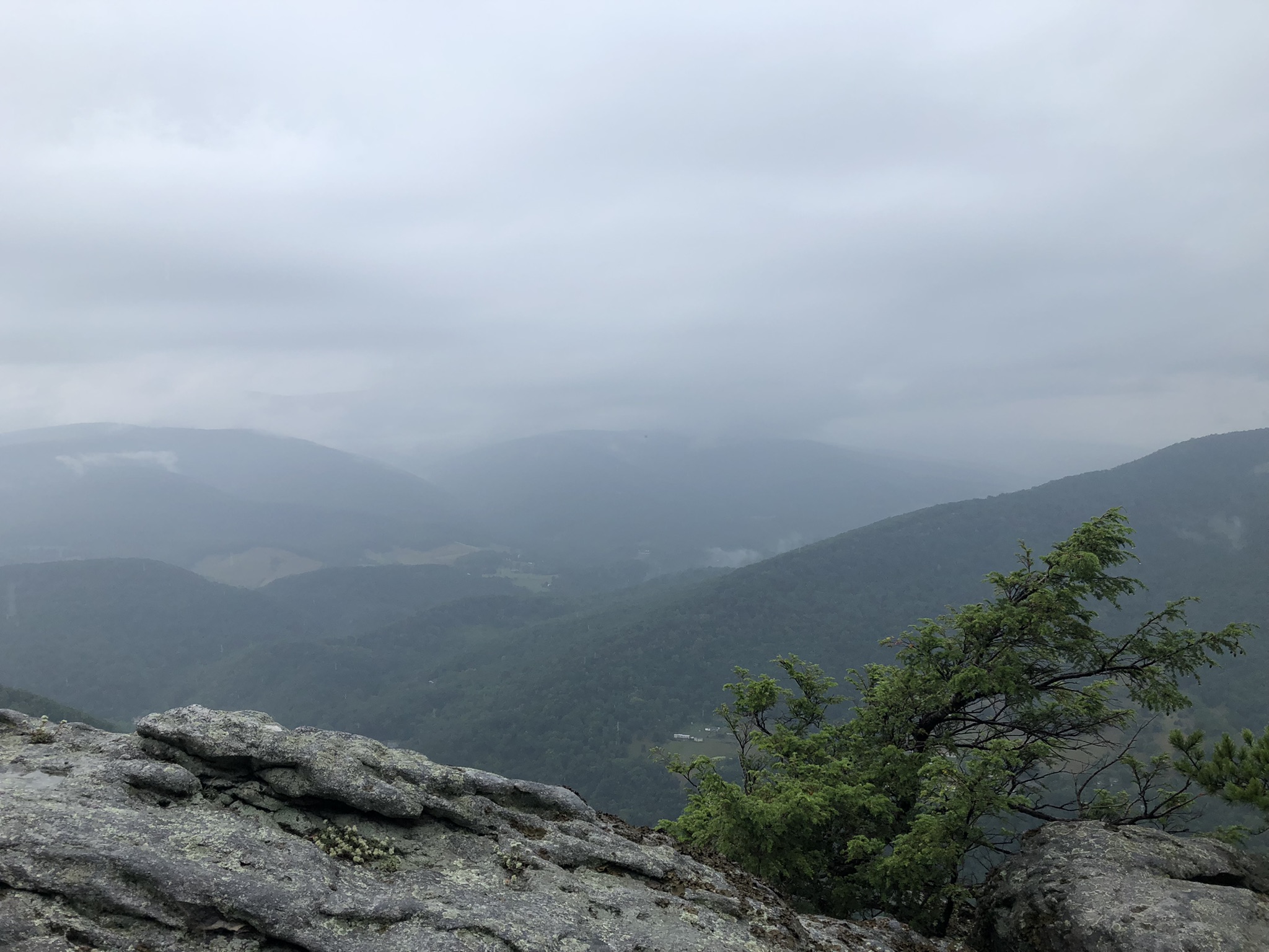
That evening, just before dark, I took another three-mile roundtrip hike out to the place where the pipeline swath plunges over the rim to the valleys below--just to see what I could see.
In these photos, I was trying to capture the mystery and the wonder of those faraway mountains on the horizon--their beckoning beauty.  But a cellphone camera is not equal to the task.
This little spot on the Roaring Plains is not new to me.  In fact, I've put up photos taken from this very place in a previous entry, I think.  There's the evil but lovely North Fork Mountain, the summit in the distance with the rocky cliffs along the ridge.  That's the place where I may or may not have encountered a serial killer...  For that tragicomedy, go HERE.  (It does sound a little hysterical...but I have since discovered that this area of West Virginia has had a number of unsolved murders in recent years--which is quite strange for a rural place.)
On the fourth day, Wednesday, I was running out of food.  But I treated it just like all the other days with reading, and lazing, and coffee-drinking, and exploring.  It was finally partly sunny, and I was surprised by how nice it was to see my old frenemy--that glaring orb--we have such a complicated relationship.  I took the Roaring Plains Trail in search of Mt. Porte Crayon.  Roaring Plains is much like Dolly Sods minus the grassy meadows with views out over the world.  It gets a whole lot fewer visitors, too.  As I followed the trail through a seemingly endless thicket of rhododendron and blueberries, I found myself thinking, "It would be nice if the vegetation would clear up a little and allow for some views.  Roaring Plains, why can't you be more like your sister, Dolly?"
There are those rare instances when the views are large, but they are often not anywhere near the main trail.  You have to really seek them out.  As I wandered the somewhat undramatic Roaring Plains Trail, I found myself thinking that this wilderness is the person you meet unexpectedly at a social event who really captures your imagination.  You really like them--their wit, their intelligence, their personality, maybe even their beauty.  But there's a guardedness to them.  They never want to tell you anything about themselves.  They never quite let you in.  You find yourself thinking, "Just open up!  I want to see more!  I know there's a lot to see and that it's magnificent.  Why can't you draw back the veil?"  In this case, a veil of rhododendrons.
After about 2 miles on the trail, the upland thickets end, and you enter a fairytale forest worthy of the Brothers Grimm.  In another half-mile, there's a lovely campsite in the pines with a view out over the rim.  When I set off that morning, I did notice a dog's fresh footprint on the trail.  Someone must have brought a dog through here last night--while I was hiking the pipeline in the evening or maybe even while I was sleeping?  Well here at this perfect campsite with long views and a soft pine needle floor, a hammock tent was strung up in the trees.  No one was there, but I didn't want to approach it.  Too bad because I did want to take a look at the view and see if Mt. Porte Crayon was visible.
Here's the view from a nearby spot.  After this campsite the trail gets very, very wet, and faint, and overgrown.  I was already hiking in wet socks and shoes from yesterday's adventures.  I HATE putting on wet socks, but I only brought one pair.  Nothing dries overnight in this kind of damp.
I went to the 3-mile point, and I began to see this summit peeking at me from the south.  At first I thought it might just be the legendary Mt. Porte Crayon, but then I noticed that it's got a radio tower on top.  And where there's a radio tower, there's got to be a maintenance road, right?  This can't be the mountain I'm looking for, can it?  There are some YouTube videos out there that try to show the way to this elusive place.  And I read that when they named the mountain in honor of the 19th century illustrator, back in 1940, they held a ceremony atop the mountain--which means there must have been a route to the top.
The Roaring Plains Trail turned into this.  A vast blueberry field, all in fruit.  You could probably pick your way through it, and you might find a faint rut beneath the foliage to indicate the trail, but it looked like a good place to turn around to me.  
As I headed back to my campsite, I ran into the fellow who got that perfect site that I'd just passed.  He's a sixth grade teacher from Ohio who just wanted to do a lone wilderness trek with his dog before school starts back up next week.  Nice guy.  He came in on Tuesday at 4:00pm and walked past my campsite without ever noticing it--thinking that he was totally alone out here in the Roaring Plains, 5.5 miles from his car.  Actually, this occurred on Wednesday afternoon; he was the first person I'd seen since the hitchhiker I'd picked up on my way in on Sunday afternoon.  (I know it's dangerous to pick up hitchhikers, especially with a serial killer roaming the mountains, but he was clearly a backpacker trying to get back to his car on the main Dolly Sods road.)
The views along my last stroll on the Plains were broad and pleasant, and I stopped to pick a lot of blueberries on my way.  Back at camp, I made lunch--Indian Korma, the last of my dehydrated just-add-water meals.  I made coffee, read some fairytales--taking notes for how to use them as sermon illustrations--and generally delayed my departure.  But about 4:00pm it was time to hike the three miles back to the car and then make the three-hour trip back to Pittsburgh.
I had really installed myself into this little spot on the Roaring Plains.  It served its purpose, too.  It gave me four days of pleasant solitude and just a little bit of beauty and discovery to boot.
Your campsite can feel like a real home for a few days, but it's never permanent.  Nothing is.  The impermanence of things is both their beauty and their tragedy.  If I come back here, I'm making for the campsite that other guy got, even if it's 2.5 miles further up.
My socks and boots were still soaked, so I did a foolhardy thing.  I hiked three miles along this road in flip-flops with my pack on my back. 
Driving down Forest Road 19, this is the view at the bottom of the mountain.  This place is just so lovely, even if there is a serial killer afoot....

Wednesday, July 27, 2022

Chimney Top and North Fork Mountain, West Virginia

This place is magnificent.  I got there on a foggy, wet day.  I checked the forecast beforehand and knew that it would be rainy and cloudy, but I didn't care.  The moment was finally upon me to visit the wondrous North Fork Mountain, and I didn't care if I got wet doing it.  This is a view from the lower reaches of the ridgeline.  
Of course, that kind of resolve is fine when you're sitting in your living room in Pittsburgh and looking at photos of North Fork Mountain online.  Actually, I'd encourage you to do that!  My photos are all too misty to capture the real magic of this place.  
I got about halfway up the mountain and it began to sprinkle, so I set up camp before reaching the vistas, not knowing that this view out over the valley of the South Fork of the Potomac River was within a quarter mile.  My plan was to have a dry base camp from which I could spend the rest of the day and much of the next exploring the rocky ridge.
Seen from afar--as from Roaring Plains--North Fork Mountain is unique because it has a series of large stone cliffs all along its western summit.  Here I am on top of those cliffs, and they are worth the hike.  It's about three miles from the small parking area on Smoke Hole Road, up the North Fork Mountain Trail--with close to 2,000 foot elevation gain--to the summit at a place called Chimney Top.
Chimney Top is a popular destination because of its enormous and unusual rock formations.  It's accessed by an unmarked side trail that you can't miss because it's worn just about as much as the main trail that it branches off from.
See the little white forms in the misty valley far below?  Those are houses on a hillside just above the Potomac.
It's hard to tell in this photo just how large these rocks are.  They're gargantuan.  I can't be sure because of the clouds, but I think you'd be looking in the direction of Dolly Sods in this shot.
There were scary little tunnels among these great rocks, and narrow ledges, and slippery-looking places where I'm sure more adventurous folk than I might venture.
I met two hikers on the way back down to my camp who told me this place was called Chimney Top.  I've since claimed it on my Peakery page, but since climbing Mt. Columbia, none of these Eastern summits seems like much.  "Comparison is the thief of joy."
Now for the strange part of my story... You know I don't scare easy, right?  I mean, I've spent the night alone in some dark and eerie places and had myself a great old time.  The forest causes you to confront whatever you're carrying around with you, and if it's fear, then it's fear you'll find among the trees.  I don't find fear.  I find beauty, and solitude, and a spiritual haven.
But my camp on North Fork Mountain just felt spooky.  When I first got to the trailhead, there was a haunted-looking guy hanging out there.  Something about his demeanor and face just felt unsavory.  He wouldn't look at me, wouldn't reply when I greeted him, but then as I was leaving to go up the mountain, I saw him staring with a spooky, intense look on his face.  I set up camp and went on up to Chimney Top and never thought about the guy again...until I saw him coming down the mountain past my campsite.  (I almost always make camp in a place invisible from the trail, but like I said, it had started to rain, so I hastily set up in the first spot I saw.)
I don't know at what point he passed me on his way up the mountain, or if he went past silently as I was setting up camp.  But it made me a little uneasy to know that the guy who gave me that weird look knew where I was camping.  I tried to put it out of my mind and went about my nightly trail rituals.  I took some books and maps and went back to one of the nearer overlooks, but there was not much to see with all the fog.  I came back and built a beautiful fire despite the rain.  But I couldn't quiet the nagging unease about my campsite, and the feeling in the woods in that place, and the weird look that scary-looking guy had given me.  Then at about 9:00pm I got an overwhelming urge to break camp and get the hell out of there, which I did.  "Trust your instincts," I told myself.  "Unless you have good reason not to, you should always trust your instincts."  Never before in all my hiking life have I done such a thing.  I stamped out the fire, threw my wet tent and all supplies into the pack willy-nilly, strapped my headlamp on and hiked two miles in the pitch dark down the mountain and to the car.  Then!  Then as I was coming upon the parking area at about 10pm, I saw through the trees another car pull in and park.  A man got out.  He was alone.  As I drew nearer I saw that it was him.  The creepy guy who gave me a weird vibe and a spooky look, the one who knew where my campsite was, he had come back at 10:00pm in the pouring rain.  Why?
I'm not saying he's the North Fork Mountain serial killer or that he had come back to murder me in my sleep...but I was sure glad to put a locked door between myself and the night.  I had seen two little motels on the outskirts of Petersburg, West Virginia, just 7 miles to the east.  Both of those were fully booked, but the kind old lady at the smaller one sent me to the Park Motel in the center of town--a very old hotel with narrow halls, rickety stairs, and bare bulbs overhead.  From the outside at night it looked kind of inviting, with hanging baskets of flowers on a broad front porch with many chairs.  Of 32 rooms, they had only six vacancies.  The motel business in Petersburg is hopping.  The eccentric old fellow at the front desk told me, "It's nothing fancy, but you'll get a clean room with a comfortable bed."  Not a bad deal for $60.
He was exactly right.  I almost thought I'd stepped into a broom closet.  A bare room with a bare bulb and no other light.  No reading lamps, no coffee pot, no carpet, no bedside table, no telephone, no internet, no curtain in the window--just a worn out venetian blind with three broken slats.  There was a small TV on a table, which I did not turn on, an old entertainment unit with a refrigerator in it, and an old kitchen chair.  The Park Motel in Petersburg, West Virginia, is basic at best.  But it was a fun discovery, and it was so much better than my campsite on North Fork Mountain.

Stonewall Jackson Monument in Clarksburg, WV

How has this statue escaped public scrutiny?  I’d long heard that it was here, in front of the Harrison County Courthouse in Clarksburg, West Virginia—exactly 100 miles south of Pittsburgh.  But I found myself in the area recently and decided to see for myself.  Jackson was a native of this area and died shortly before this part of old Virginia seceded  from Eastern Virginia to join the Union.  Not only is the Confederate general unapologetically celebrated in the precincts of a government building, but someone has recently placed a wreath of flowers at the foot of the monument.  Clarksburg was a strange place.  They’ve also got the slogan “In God We Trust” on their police cruisers and marble tablets made to look like the Ten Commandments on the steps of the courthouse.  But it’s open to interpretation because the written text of the commandments is not included, just the Latin numerals 1 - 5 on one side and 6 - 10 on the other.  Just as well.  Most people who clamor to have the Ten Commandments on our public spaces couldn’t name three of them.


Tuesday, July 5, 2022

More Scenes from Mt. Columbia, Colorado

As it turns out, Mt. Columbia will remain my only 14er--at least for the foreseeable future.  Though my time here in Colorado has been spectacular, I've met fewer goals here than I'd anticipated.  It was always meant to be a writing retreat more than a hiking retreat, and now it draws to a close.  Here are the rest of the photos I took from the top of Mt. Columbia and a few from below.
Here is Mt. Columbia from afar--from the Collegiate Peaks Overlook in the San Isabel National Forest.  Mt. Harvard and Mt. Yale do indeed cut finer forms, it's true.  Still, it's a hell of a mountain.
The wildflowers on the mountainsides were so delicate and fragrant beneath the summer sun.
There are alpine biomes up there that change rapidly as you ascend and descend.  
I think these are the little plants that smelled so strongly like cannabis.
I believe this is the shoulder--or "the traverse"--that connects Mt. Harvard with Mt. Columbia, making it possible and appealing to most peakbaggers to collect both mountaintops in one long trek.
Click on this photo to enlarge it.  Here you see Amy & Austin--which is the young couple with whom I shared much of the ascent--as well as another fellow who approached on "the traverse" from Mt. Harvard and claimed both peaks in one long hike.  The friend he was traveling with is not visible in this photo, but the mountaintop marmot is!  See him and all the others gazing down at my slow ascent.
I like the way the trail in the foreground of this photo runs along the edge of a nasty drop.  This is the long descent, which took me far longer than it took all my young fellow climbers.  As I recovered from this descent, I told myself, "No more 14ers!"  The very next day, I was busy researching 14ers I could do with my somewhat unadventurous teenage daughters.  I even preemptively purchased postcards of Mt. Sherman, Huron Peak, and Mt. Belford--thinking I'd do the first with my kids and the other two by myself.  But alas.  Now I've got some expensive postcards of mountains I've never laid eye or foot on.  Where does the time go?
Lower down on the mountainside, the trail runs like this through vast fields of stones.  See how the same trail that appears in the foreground also snakes along the shaded mountainside in the center of the photo?  Such a joy it's been to explore a bit of these mountains.

Wednesday, June 29, 2022

A Video from the Peak, Mt. Columbia

It’s not a full 360, but here’s what the world looks like from the very top of the magnificent Mt. Columbia in the San Isabel National Forest of Colorado.  It's humbling to climb one of these so-called 14ers and think that only four states in the nation have mountains as high as the one you just climbed.  Those states are California, Alaska, Washington, and Colorado.  A few of Alaska's peaks get a lot higher, but Colorado has more of them.  Somehow I just always used to assume that all the states that share the Rocky Mountain ranges had 14ers, but even Wyoming, and New Mexico, and Utah top out well below 14,000 feet.  Make it full-screen when you watch the video, but do yourself a favor and turn off the audio.  It's just the inane prattle of peak-baggers (and me), profaning a sacred moment with senseless blather....


Mt. Columbia, Colorado: My 1st 14er!

This is Mt. Columbia, as seen from its less impressive western face--the face you'll probably climb if ever you climb it.  Mt. Columbia shall forever be MY mountain.  It's the very first mountain I've ever climbed that exceeds 14,000 feet.  And--because coming down off that mountain took me so long--it might just be the last 14er I ever do.  So...it's my mountain, the one I chose, the one I climbed, the one I'll always talk about and remember.
I'm staying in Buena Vista, Colorado, and there are five "14ers" near here, all of them named rather pretentiously after prestigious universities: Princeton, Yale, Harvard, Oxford, and Columbia.  Together they're known as the Collegiate Peaks, and they're located in the incredibly beautiful Collegiate Peaks Wilderness in the San Isabel National Forest.  I had a day to devote to climbing a mountain, so I picked Columbia in much the same way I pick many things: Because, although it was good, no one else was choosing it.  If Mt. Columbia were, say, 20 miles from Pittsburgh, it would be swarming with climbers.  But because it exists in a place of so many choices, it tends to get overlooked.  Mt. Columbia is massive and beautiful, but it's the least popular of the five.  This is in part due to an infamous steep field of "scree" that causes climbers to lose the trail and to have a hard uphill slog in crumbling dirt and gravel, which makes footing treacherous.  See in this second photo how the trail hugs the mountainside.
Very close to Buena Vista is a narrow dirt lane leading into the Collegiate Peaks Wilderness.  I followed the track at 6:00am and thought, at that hour, I'd be the only person at the trailhead.  But when I got there, I found probably 30 cars already parked there.  Much to my relief, if not to my surprise, most of the people were not headed to Mt. Columbia.  They were headed for Columbia's taller and handsomer brother, Mt. Harvard.  (For me to shun you, all you gotta be is popular.)  But some of the folks there weren't headed for any mountains; they were just camping in the wilderness area, or fishing, or hiking.  I did see a mother moose and her two calves on the long road out to the trailhead.
Mountain wisdom says to go early, get up the mountain, take your selfies, and get down ASAP.  The mountains make their own weather which is unanswerable to the weather app on your iPhone.  You might see that there's only 30% chance of rain in Buena Vista, but that's 7,000 feet below the summit that you're aiming for.  Those summits typically start to collect clouds by about noon and there can be thunderstorms, rain, snow, or hail.  The later you stay up there, the more likely you are to experience any of these.  It glowered and threatened up on Mt. Columbia, starting right on schedule at noon, but the weather held the whole time I was on the mountain...which is to say 11 freaking hours!
Yes, it took me 11 hours to complete this 12-mile trek.  My guidebook listed an average hike time of 8.5 to 10 hours.  I started this trek at the parking area at 6:15am, and I didn't come trudging wretchedly back until 5:30pm--utterly spent and barely able to lift my feet.  The outward and upward leg of the journey was not too hard, the views kept getting better and better, and I was spurred on by the excitement of reaching the summit.  The return was less fun and less easy.  
Here’s a view of Mt. Columbia as seen from the Collegiate Peaks Overlook, which is in the hills east of Buena Vista.  By the time you get above the mountain’s treeline, the trail is rocky and well cared-for, as seen in the second photo.  In places, it's truly a stone staircase, where enormous natural blocks of stone have been arranged into steps, and stone guardrails have been erected, as well as stone supporting walls.  I have no idea how you do that kind of stonework on a steep mountainside, so I was pretty impressed.  
The rocky trail makes long, long switchbacks slowly up the lonely mountainside.  The climb is gradual and scenic.  But then it comes to a certain point where the switchbacks end and all you see underfoot is loose, dusty gravel and dirt.  This is the screefield.  It's long, and steep, and hazardous.  You can't really build a trail on it because it won't hold anything.  Your foot will slide on the loose dirt and gravel, but don't trust the stones here either.  Many stones look stable, but they're planted in loose earth, so your foot will cause them to slide away beneath its weight.  For many years, there was no established path up the infamous screefield on Mt. Columbia.  But within the past two years or so, someone has gone to the considerable effort of establishing a slippery route (if not a trail) through the scree.  And they've marked it with cairns.  It was sometimes hard to locate the cairns on the upward climb, but they were very visible when seen from above, on the downhill return.  
Click on this photo to enlarge it.  This little fellow here is a marmot, and she has set up her mendicant operations at the very pinnacle of Mt. Columbia.  When you top a 14er, you pull out your snacks and drinks to celebrate.  This little friend wants nothing more than to help you celebrate.  But look at the big world beyond, so vast, so lovely.  I wonder if the marmot has eyes for such a view.
Just past the screefield you're rewarded with a saddleback ridge-walk that follows the crest all the way to its peak.  It's rocky but relatively easygoing, and the views are truly amazing.  I wish I knew which of the other peaks were visible in these photos, but I don't.  I do believe the one in the background of this picture is Harvard, but I'm not sure.
Here again is the mirrorlike Bear Lake, which sits isolated and treeless high among the mountains.  It seems that there were only seven of us who peaked Mt. Columbia that day.  We all ended up meeting sooner or later either on the summit or else somewhere else on the mountain.  Four were guys in their 20s, and they peaked at Mt. Harvard first and then followed "the traverse," which is a high, treacherous ridgeline connecting Harvard to Columbia.  In fact, I got the impression that most people never bother with Columbia's peak except as a "2-fer" with Harvard's peak.  Can you imagine being noteworthy in your own right but being constantly overshadowed by others--others that are better or only slightly better than you?  That's why I chose Columbia.  I longed for its loneliness.  I related to it.  Ah, but that's just projection anyway.  The mountain is not blighted by the curse of ego.  The mountain and the marmot are free of envy, free of comparison, free of desire--except to eat, in the marmot's case.  The mountain doesn't care.
There's the summit in the center of the photo, and this is the long saddleback walk to it.  If you look closely you can see in this photo a young couple with whom I shared the trail for much of the distance.  I would pass them, then they would pass me, and the process would repeat.  It was his 38th 14er and her 1st.  She was such a sweet girl.  She asked if we could take a photo together at the top, since it was the first 14er for both of us.  But then we forgot to swap contact info in order to share the pic, and I lost them on the way back down the mountain.  Their 25-year old knees were able to take the descent A LOT faster than me.  I saw her looking back at me worriedly from time to time to see if I was okay.  I mean truly, I don't think I could have made the descent without two trekking poles, which I used like crutches at times to lower myself down onto the next stone.  I think of myself as a relatively vigorous, healthy guy--all things considered.  I'm 52 but thin and physically active.  And yet, the mountains will teach you humility.
There's snow up there year-round.  
I read in a 14er guidebook that there is delicate plant life near the mountaintops.  It was beautiful to see these unfamiliar and yet strangely lush plants growing in the rocks all along the switchback trails just above the treeline.  So many kinds of wildflowers I'd never seen before.  The guidebook also said that many of these plants can live a decade or more.  I kept thinking I smelled marijuana up there on the rocky heights, but it turns out that one of the humbler-looking plants smells remarkably like cannabis when the hot sun is on it.  
And so, will I do another 14er?  Hmm.  My kids are coming out here to join me in the near future, and I'd hate to deprive them of the opportunity of doing an easier 14er--for there are much easier ones to do!  But will 14er peakbagging become my new hobby?  No.  Like so many things, I came to it too late in life.  When I was younger and more physically capable of descending mountains, I hated Colorado for being so popular, and so I never allowed myself to embrace its wonders.  Ironic, isn't it?