Monday, November 30, 2020

Last Adventure of the Year: The Dunkenbarger Loop


My relationship with Dolly Sods Wilderness Area, in the Monongahela National Forest of West Virginia, has gone a little something like this: 1) I can't wait to go discover that place!  I've heard so much about it.  2) That was great; I can't wait to go back.  3) Why's it always so wet, and why are there always so many people, and maybe I'll start going to lonelier spots--like Otter Creek.

But it's hard, in the end, to resist the call of the fall and the lure of those mountaintop meadows.  This time around, I decided to do another lesser-visited part of the Sods known as the Dunkenbarger Loop.  It has two merciless stream crossings that tend to cull the hiker herd.  And even on Thanksgiving weekend, I had to take off my boots, roll up my pant legs, and slog ever-so-slowly over slippery rocks and through the painfully frigid water.

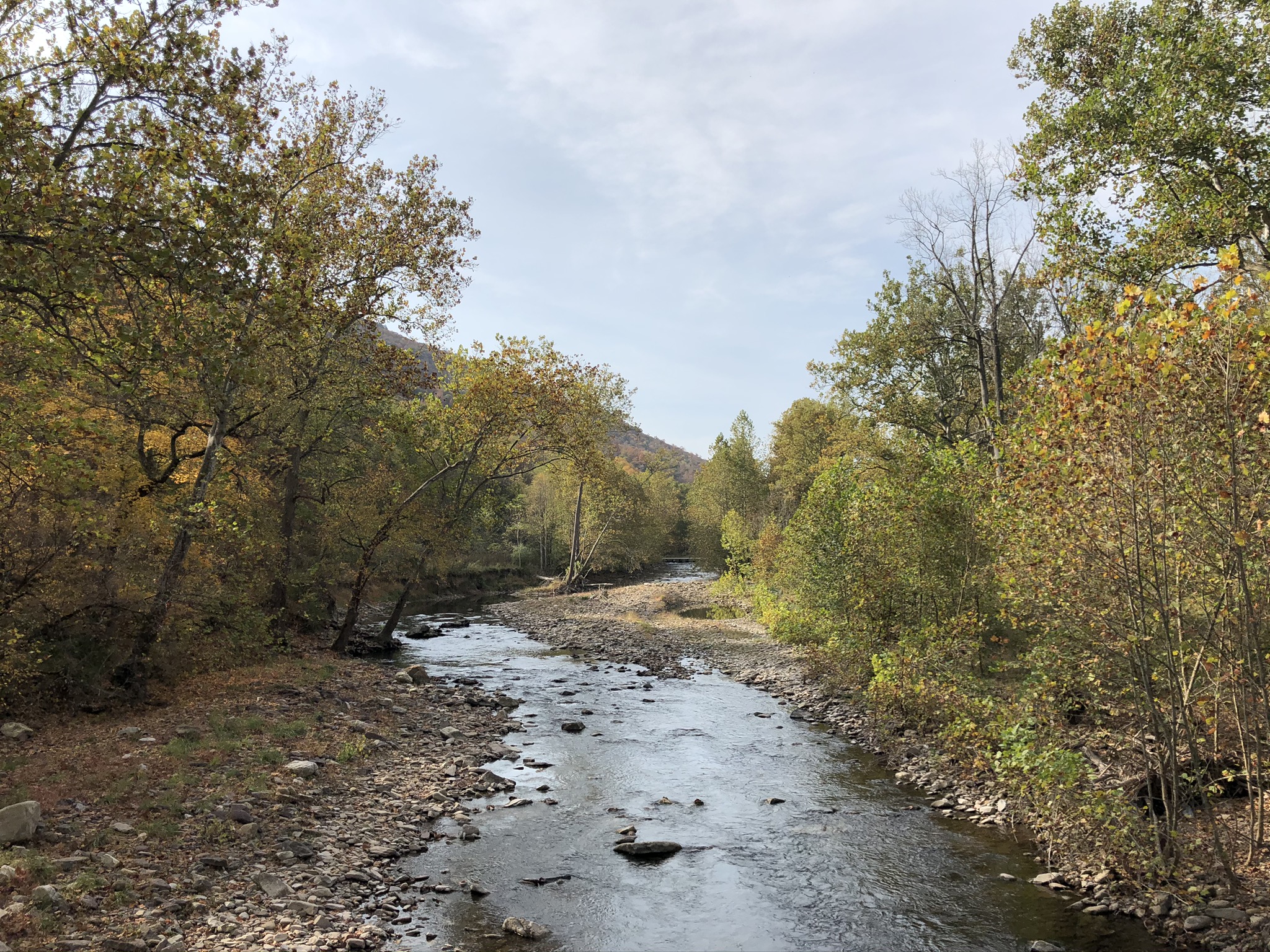
Oh, but it was worth it to get to the other side, where at least I could be forgiven for believing that I had the entire planet to myself.  This is the hard-to-reach Dunkenbarger Run, a dark, silent, fast-moving stream with tea-colored water (from the hemlock tannins).  It was a perfect spot to aim for on that first night: exactly 3 miles from my car, solitary, and pretty.

I got to Dunkenbarger Run at 4:30pm, which in November, is just before dark.  I had to scuttle to collect firewood, hang the bear bag, and put up the tent before dark.  Ah, but look at the moon rising over my ephemeral woodland home.  


On the way toward another brutal stream crossing, the following day, I came across the large and lovely campsite that was described in my guidebook.  This one is on Big Stonecoal Run.  Look at all that flat terrain, that cushiony, pine-scented turf, the sandy brook in the near distance.


This is the view from under the pines at the large campsite on Big Stonecoal Run.  Sublime.


After another bitterly cold crossing of Red Creek, barefoot, I chanced upon this wonderful spot on a bluff overlooking the creek.  The rock formations on the distant ridgeline are the Rohrbaugh Overlook, described below in an earlier post.  This is the valley that was wrapped in gray mist when I was above.


Someone has put a lot of effort into making this campsite nice, and I imagine that they're regular visitors here.  Note the railing at the edge of the bluff--which guards against a 15 foot drop onto the rocky banks below.  Again, the moon is rising above my campsite.  See the reflection on the waters of the stream.

That night was COLD!  I've never been so cold at camp, not even when I woke up to 22 degrees in the Allegheny National Forest on my last birthday.  See how all things are covered in a thin layer of hard frost!  I woke up at about 3:30am and put on just about every piece of clothing I brought, and I still shivered in my bag.


It takes the sun a long time to reach these valleys, too.  The day got as warm as 52 degrees, but not until it had exacted its toll on the ill-prepared hiker.  In another sense, I was well prepared.  I remembered that the weekend of Thanksgiving is a very popular time for hunting deer, so I bought a fluorescent orange hoodie to make myself seen.  None of the other hikers I encountered were wearing orange, and I didn't hear a single gunshot.  Maybe because, although hunting is allowed at the Sods, motorized vehicles are not, and no one wants to drag a dead dear over this terrain.  Most hunters use those golf cart-like buggies known as "gators." 


This is ice in the Nalgene water bottle that I left outside the tent.

Churches of Rural West Virginia


Wednesday, November 25, 2020

The Rohrbaugh Overlook: The Uncrowded Dolly Sods


To tell the truth, I'd begun to get bored by the legendary Dolly Sods--with its boggy trails, its open meadows, its rocks, and its mud, mud, mud.  I don't think I've ever been to Dolly Sods when it didn't rain, and when the place was not crawling with people from DC.  But then I learned about the Rohrbaugh Overlook, and I decided to give Dolly Sods another chance--a solo trip this time.

Bonner Mountain Road is a far sight better to travel in on than Lanesville Road--which is little more than a glorified, 8-mile long driveway with blind curves and steep drops and no guardrails.  The scenery is prettier on Bonner Mountain Road, too.

This is an overlook that sits right beside Forest Road 75, the main route along the eastern edge of the Sods.  I'd always seen cars parked along this part of the forest road, but it never occurred to me to stop and investigate why.  But this time, I came armed with a hiking guide book for the Monongahela National Forest, and it said that there's an overlook here where you can see all the way into Virginia.  Funny the things you can miss with years of visits and revisits...
This time around, I left Pittsburgh on a Friday at about 1:00pm.  I knew that darkness would fall at about 5:30, so I scuttled as fast as I could and reached the Fisher Spring Run Trail by 4:05.  I had a little more than an hour of rapidly fading light to find a campsite, hang the bear bag, and get a fire going.  I didn't make it to the Rohrbaugh Overlook until Sunday...but look at the beauty of it!  
Strangely, this part of the Sods--unlike the more visited reaches to the north--had very few places to camp.  When I entered the forest at the trailhead, I assumed I'd reach a campsite within minutes.  That's just the way things are up in the northern parts--campsites lining every creek, under the eaves of every evergreen grove, on the edge of every meadow.  But there weren't any established campsites for a very long time on that trail.  (Forest etiquette in the Sods is to use existing sites rather than building new fire rings.)  I finally found a suitable spot on the far side of Fisher Spring Run--maybe a mile from my car, maybe a little further.
This is another view of the valley of Red Creek from the Rohrbaugh Overlook.  Even here, there are very few campsites--but note to future self: there are some sweet ones, and a nice little creek 7 minutes away.  If this view were located two miles further north, it would be crawling with hipsters from Arlington and Bethesda.  Here, in the lesser-visited parts of the Sods, I only encountered two other hikers in two days, a couple who camped together near the overlook.
The upland meadows here are manmade.  They were carved out of the forest decades ago to provide places for deer and bear and other woodland creatures to graze and find pasture.
The fog was so thick that I feared there would be no view at all from the overlook.  But in the end the mists added to the beauty of the place.
Under less hurried circumstances, I'd have searched longer for a campsite that I liked better--though I discovered the next day that I was fortunate to get the one I got, since there were no others for a very long time.  The first night was perfect.  It fell fast all around me.  The gloaming faded quickly to the west and a lovely quarter moon rose to replace it.  It was Dolly Sods in a way that I had never experienced it before: alone both at camp and on the trails and without all the signature moors that make the place so popular.  There was plenty of rain, but a rainy day in the woods is better than a sunny day under fluorescent lights. 

Sites Homestead, Seneca Rocks

This mountain homestead dates back to 1839, when all this land was still called Virginia.


Seneca Rocks, Monongahela National Forest, West Virginia

Seneca Rocks is a lovely spot, to be sure.  This is the Potomac River!  It's little more than a trickle up here, close to its source in the West Virginia mountains.
Seneca Rocks is well worth a visit, and it's a bit of trudge getting to the top, but it's not exactly what I'd call a hike.  The trail is wide and groomed.  There's a parking lot and a visitors' center at the trailhead.  Innumerable throngs of non-outdoorsy-types make the ascent.  The view is the well-deserved reward. 
From the observation deck at the top of the mountain.
The Potomac again.
These are Seneca Rocks as seen from the parking lot.  They look more like something you'd find out west than in West Virginia.

Otter Creek Wilderness, Monongahela National Forest, West Virginia

In the Monongahela National Forest, in West Virginia (my new haven), there's a famous "wild area" known as Dolly Sods.  It's a great place with lots of upland meadows and striking views out across the nearby highlands.  Most wildlands in the East are pretty but obscured by trees, and that's what makes the Sods so special.  But Dolly Sods can be crowded, and it's always very wet.  Nearby, there's another wilderness area known as Otter Creek.
I did the southern loop in the Otter Creek Wilderness back in October.  It was lovely, though unlike Dolly Sods, much beauty was concealed by the rapidly disrobing trees.  Here's a view from Shavers Mountain looking more or less east.
Long views are rare here, but so are other hikers!  This is a larger wilderness area than the Sods, much more wooded, and far less visited.  The guy who originally told me about Otter Creek said that it's got a bad reputation because people get lost there.  I didn't find the trails too confusing because I purchased Johnny Molloy's hiking book about the Mon NF.  Without that, I'd have gotten so lost...
My friend and I set up camp right on the banks of Otter Creek, and though we did see a few day hikers on Sunday afternoon when we arrived, we encountered not another soul for the next two days.  It was really beautiful
Strangely, we didn't hear any birds at Otter Creek either.  The place was almost eerie in its silences.  You could sometimes hear trucks grinding through their gears on the hilly, distant roadway.  But no owls at night, no thrushes in the evening, no birds at all.
Coyotes there were aplenty!  They howled like a legion of unclean spirits in the ink-black night.  My friend--despite being from Texas--had never heard coyotes before...and I admit that these ones sounded especially vicious.  It gave him a bit of a fright.